Atlas of Battles

battle, major, Revolutionary and Napoleonic

Battle of Quatre Bras

Battle of Quatre Bras was a battle fought on 16 June 1815 at Quatre Bras, in what is now Belgium. It was part of the Napoleonic Wars, which ran from 1803 to 1815. The recorded result: Inconclusive. Recorded strength: 20,000–21,000 against 32,000–36,000.

See it on the globe Read the article

Prins van Oranje
Prins van Oranje. nvt, Public domain, via Wikimedia Commons.
Fought16 June 1815
WhereQuatre Bras, Belgium50.571N, 4.453E
OutcomeInconclusive
BelligerentsFirst French EmpireagainstSeventh Coalition: United Kingdom of Great Britain and Ireland
Casualties and losses4,140–4,400 killed or woundedand4,800–5,600 killed or wounded
Part ofNapoleonic Wars1803 to 1815

Where it sits in the Napoleonic Wars

Battle of Platzberg, 1794Battle of Lodi, 1796Battle of Spinges, 1797Battle of Marengo, 1800Action of 10 December 1800, 1800Battle of West Kay, 1801French capture of Gorée, 1804Battle of Pulo Aura, 1804Battle of Vizagapatam, 1804Raid on Boulogne, 1804Action of 5 October 1804, 1804Action of 10 August 1805, 1805Battle off Cape Palos, 1805Battle of Diamond Rock, 1805Battle of Memmingen, 1805Battle of Ulm, 1805Battle of Cape Ortegal, 1805Battle of Mariazell, 1805Action of 26 July 1806, 1806Battle of Blaauwberg, 1806Battle of San Domingo, 1806Action of 13 March 1806, 1806Action of 21 April 1806, 1806Action of 9 July 1806, 1806Action of 23 August 1806, 1806Action of 25 September 1806, 1806Battle of Jena–Auerstedt, 1806Action of 18 October 1806, 1806Battle of Golymin, 1806Adriatic campaign of 1807–1814, 1807Siege of Stralsund, 1807, 1807Battle of Eylau, 1807Capture of the Jeune Richard, 1807Action of 10 November 1808, 1808Battle of Kock, 1809Action of 22 January 1809, 1809Action of 10 February 1809, 1809Battle of Les Sables-d'Olonne, 1809Action of 6 April 1809, 1809Troude's expedition to the Caribbean, 1809Battle of Ratisbon, 1809Battle of the Basque Roads, 1809Battle of Stralsund, 1809Action of 31 May 1809, 1809Action of 13 September 1810, 1810Action of 3 July 1810, 1810Invasion of Île Bonaparte, 1810Action of 15 November 1810, 1810Battle of Lissa, 1811Action of 24 March 1811, 1811Action of 29 November 1811, 1811Action of 22 May 1812, 1812Battle of Pirano, 1812Action of 7 February 1813, 1813Action of 5 November 1813, 1813Battle of Varvažov, 1813Battle of Peterswalde, 1813Siege of Cattaro, 1813Siege of Zara, 1813Siege of Antwerp, 1814Siege of Ragusa, 1814Battle of Jobourg, 1814Siege of Ajaccio, 1815Battle of Montélimar, 1815Battle of Loriol, 1815Battle of Ligny, 1815Battle of Quatre Bras, 1815Battle of Waterloo, 1815Battle of Wavre, 1815Battle of Rocheserviere, 1815Battle of La Suffel, 1815Battle of the Hospital, 1815Battle of Rocquencourt, 1815Battle of Issy, 181517941815Battle of Quatre Bras, 1815
75 placed engagements of the Napoleonic Wars in time order; taller ticks are more widely documented. Each tick is a link.

Record

Date16 June 1815
PlaceQuatre Bras, Belgium
50.571N, 4.453E
KindBattle, Revolutionary and Napoleonic
Strength20,000–21,00032,000–36,000
Casualties and losses4,140–4,400 killed or wounded4,800–5,600 killed or wounded
Commanders
Battle of Quatre BrasBattle of Quatre BrasSiege of NivellesBattle of LignyBattle of FleurusBattle of FleurusBattle of FleurusSiege of NivellesBattle of LignyBrusselsCologneAntwerpenLuxembourgDüsseldorfBruggeAmiensEssen100 km50.571N, 4.453E
The recorded site, with the nearest other engagements in the atlas. Present-day coastlines, rivers and borders; towns from Natural Earth.

The ground today

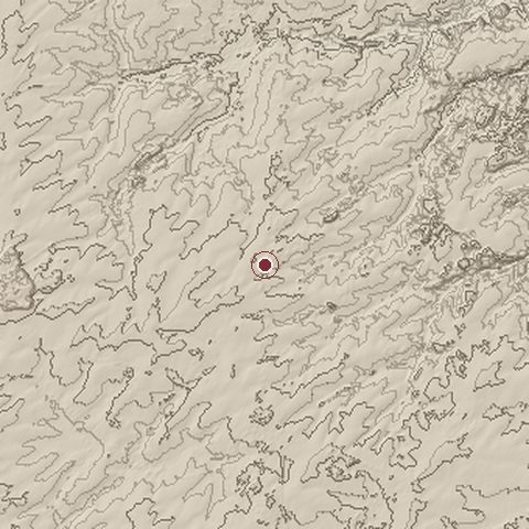
Relief of the ground around the site of Battle of Quatre Bras
Relief within about 10.0 km of the site, contours every 10 m. Copernicus DEM GLO-30, ESA.
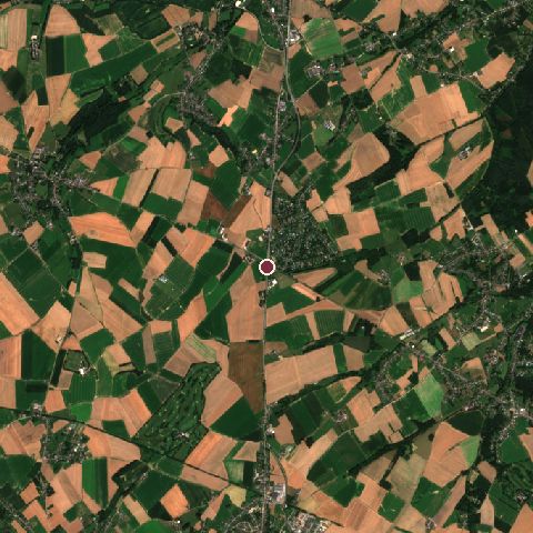
Satellite view of the site of Battle of Quatre Bras today
The same ground from Sentinel-2 on 2024-08-12. Contains modified Copernicus Sentinel data 2024.

The recorded site stands at about 156 m; within 10.0 km the ground runs from 73 to 192 m, 119 m of relief, gently rolling country and today it is 67% cropland, 15% tree cover, 14% grassland.

cropland: 67%tree cover: 15%grassland: 14%built-up: 4%cropland 67%tree cover 15%grassland 14%built-up 4%
west to east, 10.0 km113 to 179 mnorth to south, 10.0 km101 to 164 m
Elevation from the Copernicus DEM GLO-30 (ESA, Airbus); land cover from ESA WorldCover 2021 (CC BY 4.0), within about 5 km of the recorded site. Computed, not recorded.

Nearest engagements

In the same war

Elsewhere in 1815

Combat data (CDB90)

Attacker: FR ARMY OF NORTH (ELEMENTS OF)Defender: BR & DU ARMY (ELMS)
Strength26,74133,765
Casualties4,500 (16.8%)4,500 (13.3%)
Mission accomplishment, 1 to 1067
Outcomedefender won
Duration1 day
Front width5 km5 km
Attacker advanced0 km

From the US Army Concepts Analysis Agency Database of Battles (CDB90, battle 144), public domain, in the CC0 tidy edition by Jeffrey B. Arnold. Figures are the database's estimates, compiled in 1990 from published histories, and may differ from the Wikipedia infobox above.

Battle of Quatre Bras is one of 3,507 engagements of the 19th century in the atlas and one of 243 in present-day Belgium.

Sources

Identity, coordinates, dates and the war from Wikidata Q705936, released under CC0. Result, belligerents, commanders, strength and casualties from the infobox of the English Wikipedia article Battle of Quatre Bras, revision 1374209707, read 2026-11-14, licensed CC BY-SA 4.0; the article's text is not reproduced here. Present-day country and state from Natural Earth. Dates before 1582 follow the Julian calendar as recorded.