Atlas of Battles

battle, landmark, interwar and Second World War

Marco Polo Bridge incident

Marco Polo Bridge incident was a battle fought on 7 July 1937 at Lugou Bridge, in what is now People's Republic of China; it lasted 2 days. It was part of Second Sino-Japanese War, which ran from 1937 to 1945. The recorded result: See Aftermath. Recorded strength: 100 troops at the bridge; 900 in reinforcement against 5,600.

See it on the globe Read the article

​日軍炮轟宛平城。
​日軍炮轟宛平城。. Unknown authorUnknown author, Public domain, via Wikimedia Commons.
Fought7 July 1937lasted 2 days
WhereLugou Bridge, People's Republic of China39.849N, 116.213E
OutcomeSee Aftermath
BelligerentsRepublic of China (1912–1949)againstEmpire of Japan
Part ofSecond Sino-Japanese War1937 to 1945

Where it sits in Second Sino-Japanese War

Defense of Harbin, 1932Battle of Wenzaobang, 1932Battle of Nanking, 1937Siege of Shanghai, 1937Battle of Luodian, 1937Marco Polo Bridge incident, 1937Battle of Beiping–Tianjin, 1937Battle of Zhangjiakou, 1937Battle of Nankou, 1937Battle of Shanghai, 1937Battle of Wusong, 1937Battle of Taiyuan, 1937Battle of Datong, 1937Battle of Jining, 1937Battle of Xinkou, 1937Battle of Pingxingguan, 1937Defense of Sihang Warehouse, 1937Battle of Jinshanwei, 1937Defense of Linyi, 1938Siege of Xuzhou, 1938Battle of Northern and Eastern Henan, 1938Defense of Teng County, 1938Battle of Taierzhuang, 1938Battle of Xuzhou, 1938Battle of Wuhan, 1938Battle of Changsha, 1939Battle of Nanchang, 1939Battle of Suixian–Zaoyang, 1939Battle of South Guangxi, 1939Battle of Baotou, 1939Battle of Kunlun Pass, 1939Battle of West Suiyuan, 1940Battle of Wuyuan, 1940Battle of Zaoyang–Yichang, 1940Hundred Regiments Offensive, 1940Battle of South Henan, 1941Battle of Shanggao, 1941Battle of South Shanxi, 1941Battle of Changsha, 1941Battle of Changsha, 1942Battle of Tachiao, 1942Battle of Oktwin, 1942Battle of Toungoo, 1942Battle of Yenangyaung, 1942Battle of Lashio, 1942Battle of Yunnan-Burma Road, 1942Battle of West Hubei, 1943Battle of Northern Burma and Western Yunnan, 1943Battle of Changde, 1943Battle of Dushan, 1944Battle of Central Henan, 1944Operation Ichi-Go, 1944Battle of Changsha, 1944Defense of Hengyang, 1944Battle of Guilin–Liuzhou, 1944Battle of West Hunan, 194519321945Marco Polo Bridge incident, 1937
58 placed engagements of Second Sino-Japanese War in time order; taller ticks are more widely documented. Each tick is a link.

Record

Date7 July 1937
to 9 July 1937
PlaceLugou Bridge, People's Republic of China
39.849N, 116.213E
KindBattle, interwar and Second World War
Strength100 troops at the bridge; 900 in reinforcement5,600
Casualties and lossesWestern claim: 96 killed; Chinese claim: 180+ killed or woundedWestern claim: 660 killed; Japanese claim: 10 killed, 15 badly wounded, 19 lightly wounded
Commanders
  • Qin Dechun
  • Ji Xingwen
  • Feng Zhi'an
  • Jin Zhenzhong
  • Masakazu Kawabe
  • Renya Mutaguchi
  • Kiyonao Ichiki
Marco Polo Bridge incidentMarco Polo Bridge incidentSiege of ZhongduSiege of the International LegationsBattle of PekingBattle of Gaoliang RiverBattle of PalikaoSiege of ZhongduTianjinTangshanZhangjiakouBaodingChangpingChengdeXuanhuaHangu100 km39.849N, 116.213E
The recorded site, with the nearest other engagements in the atlas. Present-day coastlines, rivers and borders; towns from Natural Earth.
七七卢沟桥事变形势图
七七卢沟桥事变形势图. 竹围墙. User Zhuwq on zh.wikipedia, CC BY-SA 3.0, via Wikimedia Commons.

The ground today

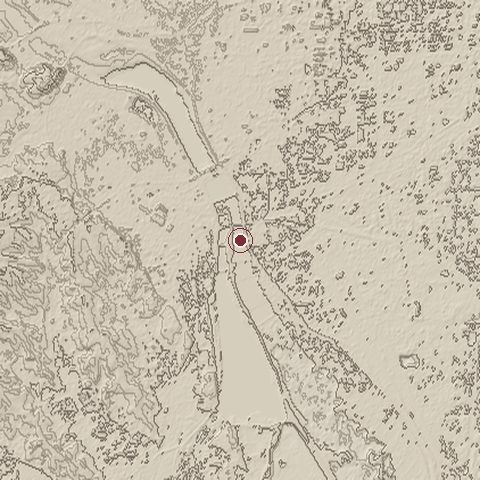
Relief of the ground around the site of Marco Polo Bridge incident
Relief within about 10.0 km of the site, contours every 10 m. Copernicus DEM GLO-30, ESA.
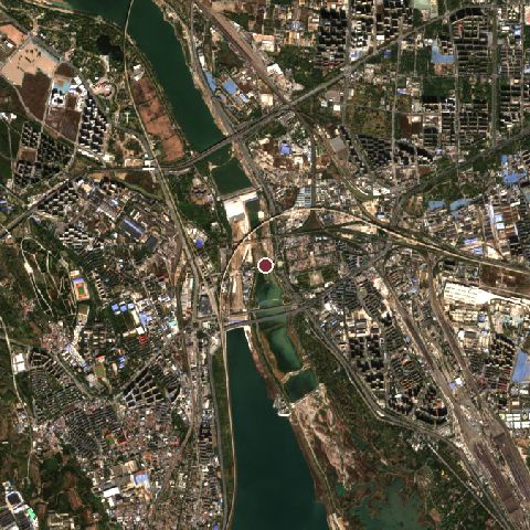
Satellite view of the site of Marco Polo Bridge incident today
The same ground from Sentinel-2 on 2024-10-28. Contains modified Copernicus Sentinel data 2024.

The recorded site stands at about 58 m; within 10.0 km the ground runs from 31 to 125 m, 94 m of relief, gently rolling country and today it is 60% built-up, 19% tree cover, 10% cropland.

built-up: 60%tree cover: 19%cropland: 10%water: 6%grassland: 3%built-up 60%tree cover 19%cropland 10%water 6%grassland 3%
west to east, 10.0 km47 to 108 mnorth to south, 10.0 km50 to 72 m
Elevation from the Copernicus DEM GLO-30 (ESA, Airbus); land cover from ESA WorldCover 2021 (CC BY 4.0), within about 5 km of the recorded site. Computed, not recorded.

Nearest engagements

In the same war

Elsewhere in 1937

Marco Polo Bridge incident is one of 2,997 engagements of the 20th century in the atlas and one of 339 in present-day People's Republic of China.

Sources

Identity, coordinates, dates and the war from Wikidata Q219230, released under CC0. Result, belligerents, commanders, strength and casualties from the infobox of the English Wikipedia article Marco Polo Bridge incident, revision 1384781150, read 2026-11-14, licensed CC BY-SA 4.0; the article's text is not reproduced here. Present-day country and state from Natural Earth. Dates before 1582 follow the Julian calendar as recorded.